Title image is phytoplankton bloom in North Sea off Scotland on 8 May 2008 taken by the MODIS instrument on-board the Aqua spacecraft. Image credit: NASA
Broadly speaking, we go to space for science for three reasons. To look outwards from Earth, to look downwards on our Earth, and for microgravity, that is, to exploit the continual freefall of being in orbit. But, you might be thinking, I can see the stars. So, why do you need to go to space to study them?
Well, the Earth’s atmosphere causes a lot of challenges to astronomy and space science. The heat haze you see on the horizon on a sunny day is caused by the atmosphere heating up and mixing. This type of disturbances is why the stars twinkle at night, and this reduces the clarity of astronomical observations, although techniques like adaptive optics and lucky imaging are increasingly able to eliminate atmosphere-induced blurring. And, the atmosphere also dims, or reduces the amount of energy in the light that makes it to the ground. In fact, it completely blocks some wavelengths of light. So, if we get above the atmosphere we can minimise these challenges. This is why so many telescopes are built at the top of mountains, but it's even better if we can go to space.
Of course, there are other reasons to go to space for science. A full-sky survey requires at least two ground-based telescopes, making rigorous maps a challenge, and if you need to make simultaneous observations that are further apart than the Earth’s diameter then you have no choice but to go into space.
Also, by studying the space environment around the Earth we can better understand how it effects our lives, and our planet. This includes everything from the charged particles from the Sun that cause the aurora’s, or northern and southern lights, to cosmic rays, high-energy protons and atomic nuclei moving at close to the speed of light and originating from the sun, from across our own galaxy, and from beyond it, that can cause temporary errors in computers, even at ground level, like corrupting a file in storage or causing a calculation to give the wrong answer. Ground-based methods for the detection of cosmic rays involve the detection of secondary or tertiary products of the collision of cosmic rays with the Earth’s atmosphere. In space, they can be detected and studied directly.
And, of course, to study the other planets in our solar system it does help if we can get a bit closer to them.
The microgravity of space also offers opportunities for science, and the International Space Station provides a convenient place to do this as it already has a lot of infrastructure to support experiments, including ample power and bandwidth to get results back to Earth. And, of course, astronauts and cosmonauts who can both run experiments and also be experimented on.
The space station currently provides the only place to study the long-term physical effects of the absence of gravity. For example, spaceflight osteopenia causes astronauts to lose, on average, more than 1% of bone mass per month in space, making them good subjects to study and learn more about osteoporosis and how to help minimise its effects.
Similar to the absence of gravity on humans, in microgravity, controls on the directionality and geometry of plant and animal cell and tissue growth can be dramatically different to those on Earth. And, microgravity can even be used to help study, and maybe one-day manufacture, novel materials and crystals. The outside of the space station is also a good place to expose different materials, over long-periods to the space environment, and then return them to Earth for study. And, we can even deploy satellites from the station.
Meanwhile, a space-based sensor for observing the Earth has many attractions. Once the satellite is deployed it can take as many images as required each time it views the area of interest, unlike an aircraft which requires a dedicated flight each time. Also, as satellites don’t require legal authorisation to view or overfly the Earth they can view any country and across borders, enabling them to analyse phenomenon at continental scale, say, geological structures, or water resources.
The increased altitude of a spacecraft verses an aircraft does tend to mean the detail in the image, that is, the spatial resolution is poorer, and a satellite sensor tends to be more complex and expensive. But, orbits can be designed to ensure a spacecraft can provide repeat images of a target region, or even the whole Earth in a much shorter time than a single aircraft could. And, using multiple spacecraft can further reduce this revisit time. Although that doesn’t mean you won’t just get more pictures of the tops of the clouds. But, using radar and infrared sensors can help image through cloud, and even at night.
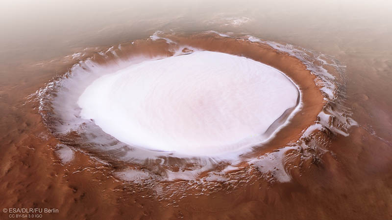
Large-scale marine and biological phenomena, such as the phytoplankton bloom shown in the title image, can actually become more apparent when viewed from space, and monitoring the oceans, for example measuring sea surface temperature or the sea state, can be undertaken more comprehensively than is otherwise affordable. Similarly, altimetry from space provides information on sea level, and the size and health of glaciers and ice-caps in detail that is otherwise near-impossible. We can even measure the shape of the Earth from space, measuring changes in ground density and level due to, say, drought or over use of underground freshwater aquifers, or underground tunnels.
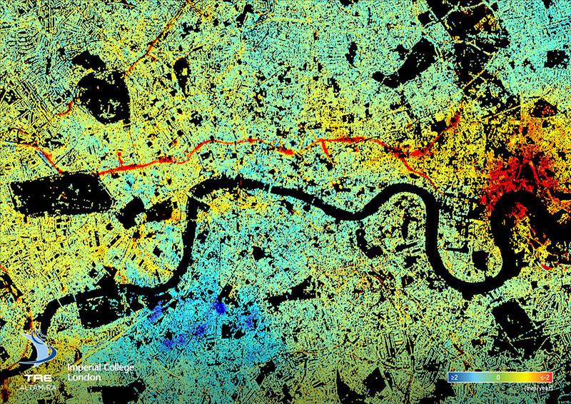
Together these insights allow us to understand the impact we are having on our planet, allowing us to monitor progress towards the UN’s Sustainable Development Goals, as well as the effects of anthropogenic climate change, from greenhouse gases and air pollution, to deforestation, and desertification, and so much more. These insights, and the collective need for them are driving more and more countries to contribute to the global Earth observation system, giving us an ever-increasing understanding of our impact on our planet, and our responsibilities to take better care of it.
Electronic & Electrical Engineering
Royal College Building
204 George St.
Glasgow G1 1XW
